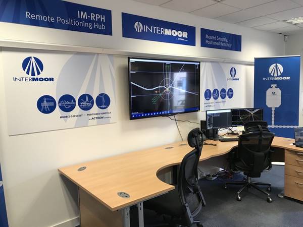
InterMoor, an Acteon company, has launched a service called Remote Positioning Hub (IM-RPH) that allows survey professionals to send navigation commands to an offshore vessel, from the comfort of their onshore base.
The new IM-RPH allows InterMoor to provide positioning services to its remotely, and it applies to various types of projects, from heading control to drillship positioning and can be transferred to rig moving, mooring projects, and other sectors like renewables such as floating wind, the company said.
This week, InterMoor’s Survey and Positioning Department will embark on their second remote positioning trial for a North Sea operator, the company said Monday.
According to InterMoor, the IM-RPH offers real-time access, as surveyors can control the navigation in real-time from their onshore facilities.
"Protected by secured firewalls, data circulates between the vessel and the onshore offices, whether it is positioning data or video/audio feeds. Sent from onshore, the commands are received offshore 0.8 seconds later," InterMoor says.
Cost cuts, emissions reduction
Also, InterMoor says the system can help optimize project resources by reducing the number of survey crew offshore. The system allows not only personnel cost reduction but also minimization of project delays that could happen due to travel hindrances (including COVID-19 quarantines) or weather events, InterMoor explains.
"With a suitable communications infrastructure, projects can be executed fully remotely. However, the IM-RPH also offers a hybrid solution, whereby shifts can be split. Personnel in the field can provide positioning services during the day and a technician onshore can provide positioning services at night," InterMoor says.
Furthermore, InterMoor says the IM-RPH enables the reactivation of skills and experience. For example, if a senior manager or subject-matter expert, who is generally onshore-based, needs to provide specialist insight into a live project, they can do so from onshore rather than having to go offshore, thereby reactivating that skill and making full use of their experience.
"It allows highly skilled personnel to be easily brought into a project for feedback and expert insight," InterMoor says.
Also, InterMoor says that reducing the number of offshore survey crew eliminates the carbon emissions from helicopter rides as well as transportation to ports and airports to send them there. It also reduces the carbon footprint from other resources (such as food and board) that would need to be used to accommodate personnel during their stay.
Steven Strathie, Survey and Positioning Manager, InterMoor Ltd, says “This new remote positioning hub bridges the gap between offshore positioning operations and onshore support and was achieved as part of a collaborative effort between InterMoor survey & positioning, Acteon IT and our clients. To do so during these challenging times shows a willingness to adapt our services and to present our clients with options in executing their own projects.”


