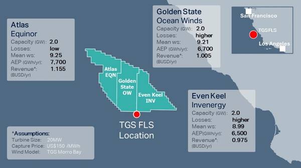
Norwegian seismic firm TGS has announced a new campaign for offshore wind and metocean measurement located in Morro Bay, off the U.S. West Coast.
This initiative further expands the company's pioneering multi-client wind and metocean measurement initiatives in key global offshore wind regions.
The campaign seeks to greatly enhance the industry's understanding of offshore conditions across three wind energy lease areas in Morro Bay by calibrating TGS proprietary wind models with observational data.
This three-year deployment in an area with an average depth of 1,000 meters will be the first by TGS on the West Coast of the United States and will add to its comprehensive library of wind and metocean data collected on the East Coast US, Norway and Germany.
The data gathered will offer crucial insights throughout the floating wind farm development lifecycle.
This includes environmental impact assessments and technical decisions such as turbine selection, layout optimization, foundation design, and operations and maintenance planning. Additionally, it will enable more accurate modeling of capital expenditures (CAPEX), operational expenditures (OPEX), potential energy production, and grid requirements.
High-quality ocean current measurements and tidal information collected over this period will prove useful for grid connection planning, while accurate atmospheric turbulence intensity observations will provide key inputs for wind farm energy yield.
Supplied by EOLOS, the buoy is equipped with advanced sensors designed to capture detailed measurements of wind, metocean, and environmental data. Key metrics include wind speed and direction at turbine hub height, wave heights, ocean current data across the full water column, and monitoring of birds, bats and fish.
Data will be continuously streamed, quality-controlled, and made available daily to customers via Wind AXIOM, TGS' site evaluation and wind data analytics platform.
As with all wind and metocean campaigns conducted by TGS, the multi-client approach will allow multiple customers to subscribe to the same floating LiDAR data, thus reducing development costs and timelines.
The deployment is supported by funding from the offshore wind industry and is expected to be launched in the third quarter of 2024.
Similar initiatives have already been successfully deployed on the East Coast of the United States, in Germany, and offshore Norway, where fleet-wide LiDAR data availability averages 94% across all TGS deployments at a 140-meter measurement height.
"TGS remains committed to supporting the growth of the global offshore wind industry. We are excited to bring our solutions to California, where floating wind technology is gaining momentum. With our multi-client floating LiDAR campaign, we make high-quality wind and metocean data more accessible, enhancing investment and planning decisions and contributing to the success of U.S. offshore wind development.
“This ninth LiDAR deployment within the last two years demonstrates our commitment and the multi- client model's continued value to the offshore wind industry. It provides superior data earlier to developers worldwide, helping them reduce risk throughout the project lifecycle,” said Kristian Johansen, CEO of TGS.